
Ionospheric Structure
The Earth's ionosphere and plasmasphere introduce challenges to the calibration of the MWA due to its operation at low frequencies (<300 MHz). As a result of the required careful calibration of the array to compensate for refractive errors of the received radio signals due to the plasma, the MWA will be capable of determining ionospheric variations on short temporal (~10 sec) and spatial (~ 1 km) scales. This by-product which yields 'relative' ionospheric variations over the array can then be used to study ionospheric structure.
In addition to the observations of relative ionospheric structure from the MWA calibration system, there is a need for 'absolute' determination of ionospheric and plasmaspheric electron content to correct for Faraday rotation of radio sources as part of the heliospheric study outlined above. The ionosphere and plasmasphere introduce a rotation of the same magnitude as expected from the heliosphere, and therefore must be accurately compensated. For this absolute measurement of ionospheric-plasmaspheric electron content and Faraday rotation, it is planned to utilize GPS observations, aided by empirical models where necessary.
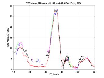 Three dual-frequency GPS receivers (GSV4004B with Novatel GPS702 antennas), provided by AFRL/AFOSR, are planned for deployment at the MWA site. In December 2006, the GPS systems were tested at Haystack Observatory and were operated simultaneously with the Millstone Hill Incoherent Scatter Radar (ISR) to validate their performance. The figure (J. Salah) shows the variation during the period 13-15 December 2006 of total electron content (TEC) in TECunits (1 TECU=1016 electrons/m2) with time, shown in hours from start of experiment at 12 UT on 13 December. The GPS measurements were obtained with one of the MWA GPS receivers using signals from various GPS satellites viewed from Haystack at high elevation. The red curve is the result of integrating high-resolution (3 km) profiles of electron density from the ISR over the altitude range 100-1000 km.
Good agreement is found between the GPS and ISR, with evidence of plasmaspheric contribution to TEC (1000-22000 km) of about 3 TECU during the daytime on 13 December (~18 UT). A major magnetic storm occurred on 14 December resulting in an enhancement of TEC by a factor of 2, depletion of the plasmasphere, and occurrence of large oscillations (2-3 TECU) during the night after the storm (48-56 UT). In the recovery phase from the storm on the following day (15 December), the TEC remained low with only 5 TECU recorded by both the ISR and GPS.
Presently, the three GPS receivers have been deployed at the MWA site in Boolardy, Western Australia, and TEC observations commenced in August 2008. Two of the receivers are deployed at a baseline distance of ~35 km with the third to be installed at an equivalent distance perpendicular to the first baseline forming a triangle around the MWA. The MWA GPS receivers will also be combined with other receivers in Western Australia which will form an important product for the overall study of ionospheric structure in the southern hemisphere. The MWA location in Western Australia represents a mirror conjugate point to the American sector in the northern hemisphere and is at roughly the same geomagnetic latitude as the Caribbean area which has been found to be a source of large plasma enhancements during solar storms resulting in the propagation of plumes of ionization that cause serious space weather effects on navigation signals. Whether similar behavior is found in the southern hemisphere will be determined from the planned observations.
Copyright © 2009 Murchison Widefield Array. All rights reserved. | MWAinfo@MWAtelescope.org
